

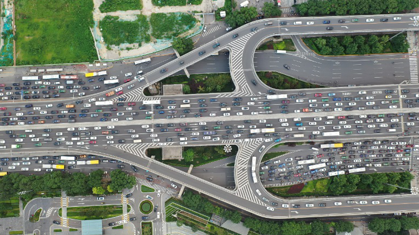
In order to support the development of a new generation of micro traffic simulation system and explore and promote micro traffic behavior modeling research from a new perspective, Beijing Transport Institute (BTI) began to invest in the research of road traffic flow aerial photography and trajectory recognition technology based on artificial intelligence in 2019, Build a high-precision standardized trajectory database traffichut (high definition unified trajectory dataset). Different from traditional GPS track data and on-board natural driving data, traffichut database includes three sub databases: video library, track library and feature library:

4K resolution aerial video

Extracting vehicle trajectory data from video

Feature classification information corresponding to trajectory
1200Metres
Covering up to 1.2km of roads
0.04Seconds
Track information of all vehicles with 0.04 second accuracy

Traffic HD aerial video

Track recognition technology of aerial video

Research on traffic micro behavior

Construction of traffic micro behavior model
Traffichut takes data disclosure and data sharing as the core idea, builds a vehicle trajectory sharing data platform all over the world, and promotes the development of traffic neighborhood research. Compared with the single vehicle data of on-board natural driving, traffichut can cover and provide the trajectory information of all vehicles within the range, which is conducive to analyzing the interaction of vehicles among groups. Compared with traditional GPS trajectory data, traffichut has higher spatio-temporal data accuracy:
0.04Seconds
The time granularity can reach 0.04 seconds
0.5Metres
The spatial accuracy is less than 0.5m
4k25 frames, high-quality original video with stable picture
High robust vehicle recognition and trajectory tracking algorithm to ensure trajectory quality
单个点位早高峰或晚高峰的拍摄时间跨度为约1.5小时 The shooting time span of morning peak or evening peak at a single point is about 1.5 hours
Continuous trajectory of single hover for 5 ~ 15 minutes
1-4 aircraft in a single flight, covering about 350 ~ 1200 meters of roads
70 hour aerial video of 19 intersections + 26 expressways in Beijing has been processed
By the end of 2021, 100000 tracks will be cleaned and checked, and authorized downloads will be gradually opened. Submit videos or tracks that meet the requirements, participate in co construction and obtain richer data
The abbreviation of hut in traffichut means "shared cabin". Relying on the Beijing Key Laboratory of urban traffic operation simulation and decision support, Beijing Transportation Development Research Institute calls on powerful institutions and individuals around the world to participate in the construction of this shared database and explore the micro traffic behavior modeling method from a new perspective, Promote the research on micro behavior modeling and the research and development of a new generation of micro traffic simulation system.
 HeBane
2021-05-13
HeBane
2021-05-13


回到顶部